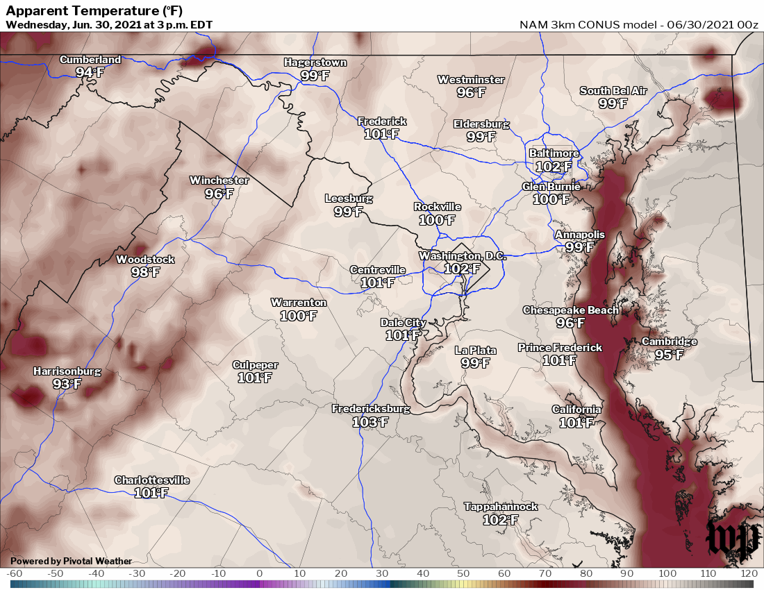
 D.C. area heat index expected to peak near or past 100 degrees this afternoon. (Pivotal Weather/CWG) | Today's daily digit A somewhat subjective rating of the day's weather, on a scale of 0 to 10. 2/10: The peak of this week's heat, as the heat index aims for 100+. Express forecast - Today: Scorching hot and humid. Highs: Mid-to-upper 90s.
- Tonight: Warm and muggy, scattered storms possible. Lows: Mid-70s.
- Tomorrow: Partly sunny, p.m. storms likely. Highs: Near 90 to low 90s.
Forecast in detail Our heat wave may pale in comparison to the Pacific Northwest. But it's still hot, still humid, and still potentially dangerous if exposed for any extended period of time. So try to stay cool as we get through the peak of the heat today. Tomorrow is only slightly cooler with a good chance of storms, followed by noticeably cooler weather with some rain into the holiday weekend. Today (Wednesday): We're set to bake again under mostly sunny skies. Morning temperatures quickly rise into and through the 80s. Afternoon highs top out in the mid-to-upper 90s with the heat index peaking around 100-105 (even though humidity may be slightly lower than yesterday). That is dangerous heat so limit your time outside late morning through afternoon. Winds are light from the southwest with just a slight chance of a late-afternoon shower or storm. Confidence: High Tonight: Temperatures hover in the muggy 80s through much of the evening. Could see some scattered showers and storms this evening, mainly between 7 p.m. and midnight. Otherwise we're partly cloudy with lows in the mid-70s. Confidence: Medium-High Follow us on Facebook, Twitter, and Instagram for the latest weather updates. Keep reading for the forecast through the weekend... Tomorrow (Thursday): We get off to a similar start to today with temperatures quickly rising into the 80s. The difference being some added clouds, we'll call it partly sunny, as a cold front approaches. That should hold highs back just a bit, topping out near 90 to the low 90s, and also brings a good chance of strong to severe storms during the afternoon into evening. Confidence: Medium-High Tomorrow night: Showers and storms remain possible during the evening and overnight, but should diminish in coverage and intensity. Otherwise we're not quite as warm as recent nights with lows near 70. Confidence: Medium A look ahead Scattered showers likely with a few thunderstorms possible on Friday as the front lingers nearby. We're noticeably cooler, with only moderate humidity, as afternoon highs reach the upper 70s to low 80s. Can't rule out a few lingering showers or a thundershower Friday night as lows fall back into the 60s. Confidence: Medium The weekend forecast could trend drier as we get closer, but for now scattered showers and a few thunderstorms remain possible Saturday into Saturday night with mostly cloudy skies and highs near 80, and a few showers and a storm could linger into Sunday (Independence Day) with partly sunny skies and highs in the low-to-mid 80s. Humidity isn't too bad either day with dew points near 60. Confidence: Low-Medium Rain chances look to diminish as we get toward and into Sunday evening, so as of now we're looking alright for fireworks and related activities with temperatures dropping back through the 70s. Then Monday looks dry and mostly sunny with warmer highs in the mid-80s to near 90. Confidence: Medium | 

