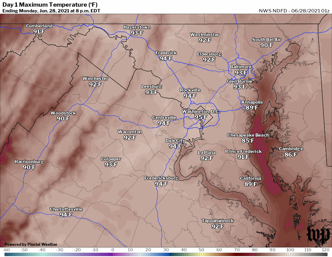
 Forecast high temperatures on Monday from the National Weather Service. | Today's daily digit A somewhat subjective rating of the day's weather, on a scale of 0 to 10. 3/10: Lots of sun, but so steamy. Stay cool today. Express forecast - Today: Mostly sunny, humid. Highs: 91 to 95.
- Tonight: Partly cloudy. Lows: 69 to 76.
- Tomorrow: Mostly sunny, humid. Highs: 92 to 96.
Forecast in detail This heat is nothing like what the Pacific Northwest is enduring, but it'll still be pretty miserable through midweek. The combination of heat and humidity will make it feel like 100 to 105 in the peak of the afternoon. A strong, slow-moving cold front approaching and moving into the region Thursday through Saturday is likely to set off numerous showers and storms, some of which could be intense. More tranquil weather should arrive by Independence Day. Today (Monday): The sun beats down, and it's a hot day. Highs climb into the low to mid-90s and with moderately high humidity (dew points near 70), it feels like 100. The light breeze from the south at 5 to 10 mph doesn't do much to take the edge off the heat. Confidence: High Tonight: Mostly clear to partly cloudy skies and muggy. Lows range from near 70 in our cooler spots to the mid- to upper 70s downtown. Confidence: High Follow us on Facebook, Twitter, and Instagram for the latest weather updates. Keep reading for the forecast through the weekend... Tomorrow (Tuesday): This day is more or less a repeat of Monday but perhaps a degree or two hotter. Many places may see highs up to around 95 and, with the humidity, it feels like 100 to 104. Continued light winds from the south. Confidence: High Tomorrow night: Another warm, humid summer night. Lows range from near 70 in our cooler spots to the upper 70s downtown. Soft breezes from the southwest are hardly noticeable. Confidence: High A look ahead Wednesday is probably the week's hottest day, with highs in the mid-90s and a few upper 90s not out of the question. Heat index values of up to 105 are possible, and we could see heat advisories issued. A pop-up, late-day shower or storm cannot be ruled out (20 to 30 percent chance), but most of us remain dry. A muggy night follows, with lows in the 70s. Confidence: Medium-High It's still hot and humid on Thursday but increasing clouds and storms ahead of a powerful cold front probably mean it's not as hot as preceding days. Ingredients may come together for some storms to become severe. Highs are near 90 with lows 70 to 75 Thursday night. Confidence: Medium Additional showers and storms are a good bet Friday and possibly Saturday (rain chances will decrease some as the day wears on), depending on how fast the front pushes through the region. Periods of heavy rain are possible, especially Friday. Highs are mostly in the 80s with lows 65 to 70. Confidence: Low-Medium Fingers crossed that the front is through the area on Sunday, Independence Day. Right now, we'll call for partly cloudy skies and highs in the mid-80s, but can't totally rule out showers. Stay tuned as the forecast comes into better focus. We can say for sure that it will not be a particularly hot day, which is encouraging. Confidence: Low-Medium | 

