 Radar courtesy MyRadar | © OpenStreetMap contributors | * Flash flood watch for eastern part of region this afternoon through Friday morning | Tropical storm warning for Calvert and St. Mary's counties * Today's daily digit A somewhat subjective rating of the day's weather, on a scale of 0 to 10. 3/10: Elsa makes her approach, clouds and showers encroach. Express forecast - Today: Increasing clouds, possible afternoon showers/downpours. Highs: 85-89
- Tonight: Evening rain gradually diminishes, breezy. Lows: 65-71
- Tomorrow: Partly sunny, chance of p.m. storms. Highs: 87-91
Forecast in detail What is left of Tropical Storm Elsa should come close enough this afternoon and tonight to produce some rain, with the heaviest amounts east of Interstate 95. Unfortunately, humidity persists even after Elsa departs, and afternoon-evening showers and storms remain a risk through the weekend. Don't ditch the outdoor plans, just keep an eye on the radar. Today (Thursday): Sunshine gets an early start but clouds are likely to begin filtering it as the morning progresses. Showers and perhaps a thunderstorm are possible anytime this afternoon but should be mainly focused late in the day. Humidity remains high with dew points in the low 70s. Highs peak in the mid- to upper 80s. Breezes are light from the south. Confidence: Medium-High Tonight: Elsa makes its closest approach to the area in the evening, bringing a chance of rain, especially near and east of I-95, where it could be heavy and even cause some spotty flooding. Winds could be gusty for a time, especially near the Chesapeake Bay. Total rainfall may be around half an inch in the immediate area, but 1 to 3 inches toward Southern Maryland. There may be a sharp cutoff in amounts west of the Beltway. Most of the showers should pull away from the area after midnight. Overnight lows range from the mid-60s to low 70s. Confidence: Medium 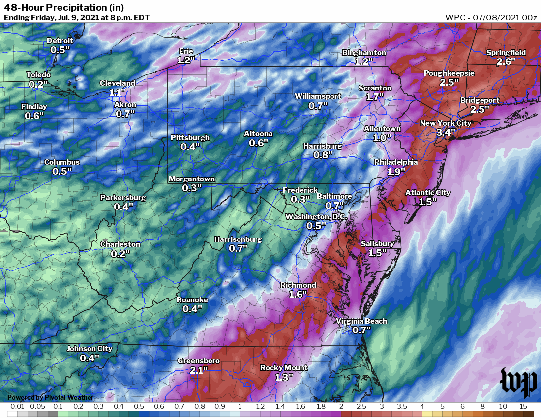 Forecast rainfall through Friday from the National Weather Service. (PivotalWeather) | Follow us on Facebook, Twitter and Instagram for the latest weather updates. Keep reading for the forecast through the weekend … Tomorrow (Friday): Skies clear in the morning, but as the afternoon progresses, scattered showers/storms may pop up to our west and cross the area with scattered downpours. Highs top out in the upper 80s to low 90s and humidity remains high. Winds are light from the west. Confidence: Medium-High Tomorrow night: Showers should taper off after sunset with gradually clearing skies. Lows drop to the mid- to upper 60s. Confidence: Medium-High A look ahead Saturday looks most friendly to outdoor activities. Humidity slackens to moderate levels and highs are mainly in the mid-80s. Skies are mainly sunny with just a slight chance of a pop-up afternoon shower. Overnight lows are mainly in the upper 60s under partly cloudy skies. Confidence: Medium-High A storm stalled over the Midwest on Sunday and Monday is still likely to spin off a few showers/storms with the greatest risk of getting wet late each day. Highs are mainly in the upper 80s with a few low 90s, and humidity is back to uncomfortably high levels. Lows hold in the upper 60s to low 70s. The sliver of a new crescent moon on the western horizon with Mars and Venus in conjunction is likely to be obscured early Sunday evening but has a better chance to be seen Monday evening. Confidence: Medium | 

