 Radar courtesy MyRadar | © OpenStreetMap contributors | Today's daily digit A somewhat subjective rating of the day's weather, on a scale of 0 to 10. 6/10: I'll take the relative cool, although I'd also like to hit the pool. Express forecast - Today: Mostly cloudy. Showers or rain, focused south and east. Highs: 78-85.
- Tonight: Evening rain chance. Clearing Lows: 63-68.
- Tomorrow: Mostly sunny. Highs: Near 90.
Forecast in detail A weak coastal storm passing by today marks the end of our generally temperate start to August. Most of the heavier rain may stay just to our southeast, but we should see enough cloud cover to keep readings muted. Once this little storm is out of here a heat dome is expanding into our region off the Atlantic Ocean. That's usually a recipe for a hot and humid stretch this time of year. Today (Saturday): Clouds are numerous through the day. Showers and perhaps some storms try to move in from the south during the morning into midday. The best time for consistent rain seems to be midday into the afternoon. There should be a sharp edge to the rainfall amounts, and we're right near it. The best odds of substantial rain are across Southern Maryland and to the east or northeast from there. Several inches could fall in the heaviest stuff to the south and east, while northwest suburbs might see nothing. Highs range from the upper 70s where rain is most common south and east to perhaps the mid-80s north and west. Winds are light from the south and southeast. Confidence: Medium Tonight: If any showers remain, rain chances end from west to east through sunset. Overnight, skies trend clearer as temperatures fall into the 60s for lows. Some patchy fog may develop, especially where it rains the most. Confidence: Medium-High Follow us on Facebook, Twitter, and Instagram for the latest weather updates. Keep reading for the forecast through the weekend... Tomorrow (Sunday): We may still be kicking out some of the clouds from overnight, but the day ends up mostly sunny. With return of near-full sunshine, temperatures respond by rising to around 90 for afternoon highs. Winds blow from the southeast around five to 10 mph. Confidence: High Tomorrow night: Skies are mainly clear. With higher humidity than recently, readings don't dip too far overnight. I think mainly upper 60s and lower 70s should do it. Confidence: Medium-High 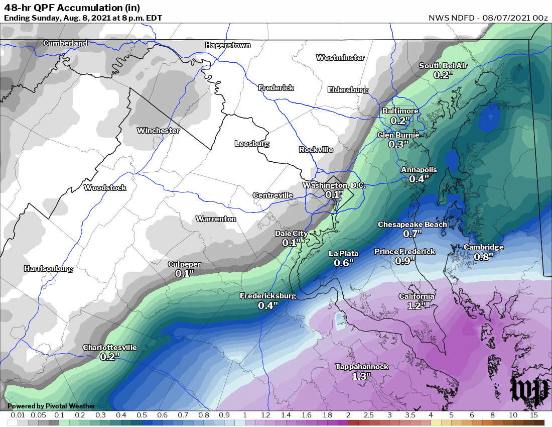 Rainfall forecast from the National Weather Service as of last night. | A look ahead Sunshine is going to be abundant Monday as high pressure builds in further. High temperatures seem likely to end up near or a bit above 90. Just an outside shot at a late-day shower or storm, but I think most of that is in the mountains to the west. Confidence: Medium-High Plan on more of the same into Tuesday. Heat and humidity are both up. Some bubbly clouds pop up in the midday heat and it looks like we could have a somewhat better chance at afternoon storms compared to Monday. Before any of that, high temperatures reach the low to mid-90s, with a heat index nearing 100. Confidence: Medium | 

